Figure:Mt Vesuvius 79 AD eruption-la.svg

Risoluzion plene (file tal formât SVG, dimensions nominâls 800 × 480 pixels, dimensions dal file: 86 KB)
Descrizion
| Descrizion |
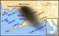
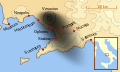
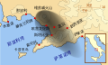
English: A map showing the cities and towns (with their Latin names which were affected by the eruption of Mount Vesuvius in 79 AD ; the general shape of the ash and cinder fall —see w:en:pyroclast— is shown by the dark area to the southeast of Mt Vesuvius.
This map shows modern day coast lines and uses the Mercator projection (although that is not important on a map of this scale). North is, as usual, at the top of the map. Español: El mapa muestra las ciudades y los poblados (con sus nombres en latín) que fueron afectados por la erupción del Vesubio del año 79 d.C. ; las cenizas y los residuos de la erupción volcánica —consultar Piroclasto (tefra)— cayeron al sureste del Monte Vesubio, donde está indicado por la zona oscurecida. |
| Date | |
| Sorzint | Opere personâl |
| Autôr | MapMaster |
References
This map is intended to show the general distribution of (airborne) ash punice, and other particles. I built the map from descriptions of the event as well as these maps:
- Luongo, Giuseppe; Perrotta, Annamaria; Scarpati, Claudio;De Carolis, Ernesto;Patricelli, Giovanni;Ciarallo, Annamaria (2003) "Impact of the AD 79 explosive eruption on Pompeii" in Journal of Volcanology and Geothermal Research v126 pp. 169-200.
- This map.
- Image:Pompeya, el Vesuvio y su alcance.jpg
Other versions
[]
-
 English
 -
 français
 -
 Latina
 -
 Nederlands
 -
 português
 -
 македонски
 -
 русский
 -
 中文
中文 -
 עברית
עברית


|
Questo file SVG contiene del testo che può essere facilmente tradotto nella tua lingua, utilizzando un editor che supporta SVG (ad esempio un editor XML o di testo). Per maggiori informazioni vedi: Tradurre un file SVG. |
Licence pal ûs

|
Tu puedis copiâ, distribuî e/o modificâ chest document su la fonde de licence GNU Free Documentation License, Version 1.2 o seguitivis pubblicadis de Free Software Foundation; sence nissune sezion no modificabil, sence un testo di copertine e sence un test di quarte di copertine. Una copie de licence si ciate inte sezion intitulade Testo della GNU Free Documentation License. |
- Tu sês libar/libare
- di condividi – di copiâ, distribuî e trasmeti il lavôr
- di modificâ – di adatâ il lavôr
- A lis cundizions seguitivis
- Atribuzion – Tu âs di dâ lis informazions adeguadis sul autôr, un leam ae licence e dî se a son stâts cambiaments. Tu puedis fâ chest in cualsisei mût rasonevul, ma no in maniere di fâ pensâ che e avaledin te o la maniere che tu dopris la opare.
- condivît inte stesse maniere – Se tu modifichis, cambiis o tu amplis il materiâl, tu scugnis distribuî i tiei contribûts in base ae stesse licence o compatibil cul origjinâl.
Storic dal file
Frache suntune date/ore par viodi il file cemût che al jere in chel moment.
| Date/Ore | Miniature | Dimensions | Utent | Coment | |
|---|---|---|---|---|---|
| atuâl | 6 di Avr 2018 a lis 10:00 | | 800 × 480 (86 KB) | -donald- | K changed to km |
| 29 di Nov 2014 a lis 00:04 |  | 800 × 480 (88 KB) | Ras67 | frame removed | |
| 19 di Otu 2007 a lis 02:17 |  | 659 × 396 (113 KB) | MapMaster | slight modification | |
| 16 di Otu 2007 a lis 00:35 |  | 659 × 396 (113 KB) | MapMaster | slight image fix-up | |
| 15 di Otu 2007 a lis 19:52 |  | 652 × 396 (113 KB) | MapMaster | == Summary == {{Information |Description=A map showing the cities and towns affected by the eruption of Mount Vesuvius in 79 AD. The general shape of the ash and cinder fall (see w:en:pyroclast) is shown by the dark area to the southeast of Mt Vesuvi |
Ûs dal file
Lis vôs ca sot a son leadis a cheste figure:
ûs globâl dal file
Chestis altris vichis a doprin chest file:
- Ûs in af.wikipedia.org
- Ûs in bg.wikipedia.org
- Ûs in br.wikipedia.org
- Ûs in ca.wikipedia.org
- Ûs in cs.wikipedia.org
- Ûs in da.wikipedia.org
- Ûs in de.wikipedia.org
- Ûs in de.wikivoyage.org
- Ûs in en.wikipedia.org
- Ûs in es.wikipedia.org
- Ûs in et.wikipedia.org
- Ûs in fi.wikipedia.org
- Ûs in fr.wikipedia.org
- Ûs in fy.wikipedia.org
Mostrel'ûs globâl di chest file.