Figure:Cooks Karte von Neufundland.jpg

Dimension di cheste anteprime: 615 × 599 pixels. Altris risoluzions: 246 × 240 pixels | 492 × 480 pixels | 788 × 768 pixels | 1 051 × 1 024 pixels | 1 500 × 1 462 pixels.
Risoluzion plene (1 500 × 1 462 pixel, dimensions: 521 KB, gjenar MIME: image/jpeg)
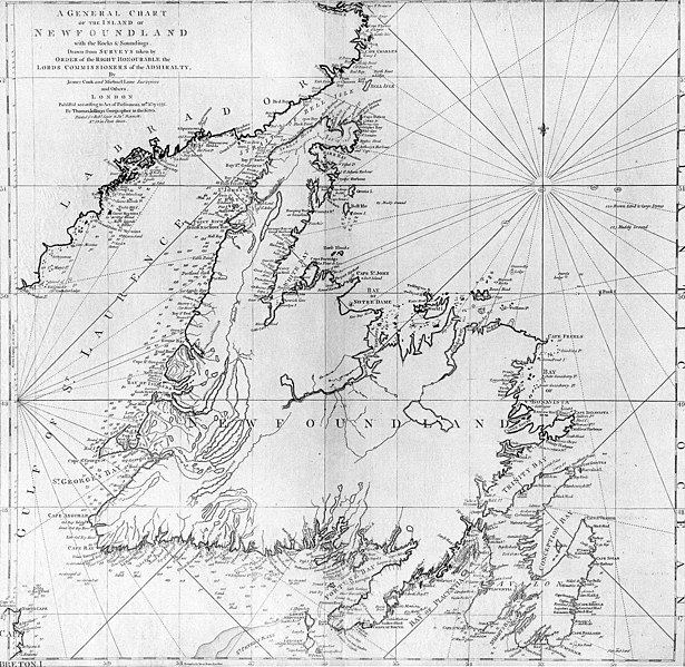
| Descrizion | A general chart of the island of Newfoundland. Surveyed by James Cook and Michael Lane, and "publish'd according to Act of Parliament by Thomas Jefferys Geographer to the King, 1775." |
| Date | |
| Sorzint | originally uploaded to en.wikipedia by Jcmurphy on 23 Apr 2005; copied from "Courtesy of the Centre for Newfoundland Studies, Memorial University of Newfoundland, St. John's, Newfoundland." |
| Autôr | Michael Lane and James Cook |
| Permès (Torne a doprâ chest file) |
Public domain because of age |
|
Quest'opera è nel pubblico dominio anche in tutti i Paesi e nelle aree in cui la durata del copyright è la vita dell'autore più 100 anni o meno. | |
| Questo file è stato identificato come libero da restrizioni conosciute riguardanti le leggi sul copyright, compresi tutti i diritti connessi e vicini. | |
Storic dal file
Frache suntune date/ore par viodi il file cemût che al jere in chel moment.
| Date/Ore | Miniature | Dimensions | Utent | Coment | |
|---|---|---|---|---|---|
| atuâl | 6 di Zen 2006 a lis 21:10 | | 1 500 × 1 462 (521 KB) | Schaengel89~commonswiki | {{Information| |Description =A general chart of the island of Newfoundland. Surveyed by James Cook and Michael Lane, and "publish'd according to Act of Parliament by Thomas Jefferys Geographer to the King, 1775." |Source =originally yuploaded to |
Ûs dal file
Lis vôs ca sot a son leadis a cheste figure:
ûs globâl dal file
Chestis altris vichis a doprin chest file:
- Ûs in bs.wikipedia.org
- Ûs in ca.wikipedia.org
- Ûs in de.wikipedia.org
- Ûs in en.wikipedia.org
- Ûs in en.wikivoyage.org
- Ûs in eo.wikipedia.org
- Ûs in es.wikipedia.org
- Ûs in fi.wikipedia.org
- Ûs in fr.wikipedia.org
- Ûs in ga.wikipedia.org
- Ûs in gl.wikipedia.org
- Ûs in he.wikipedia.org
- Ûs in hy.wikipedia.org
- Ûs in ia.wikipedia.org
- Ûs in it.wikipedia.org
- Ûs in ja.wikipedia.org
- Ûs in ka.wikipedia.org
- Ûs in ko.wikipedia.org
- Ûs in la.wikipedia.org
- Ûs in li.wikipedia.org
- Ûs in lt.wikipedia.org
- Ûs in mk.wikipedia.org
- Ûs in ne.wikipedia.org
- Ûs in no.wikipedia.org
- Ûs in oc.wikipedia.org
- Ûs in pl.wikipedia.org
- Ûs in pl.wiktionary.org
- Ûs in pt.wikipedia.org
Mostrel'ûs globâl di chest file.